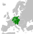
Wêne:German Confederation (1815).svg

Dosyeya orjînal (Daneya SVG, mezinbûna rast: 450 × 456 pixel; mezinbûna daneyê: 801 KB)
| Ev pel ji Wikimedia Commonsê ye. Agahdariya li ser rûpela danasîna pelê li jêr tê nîşandan. |
Captions
Items portrayed in this file
motîv Kurdish (Latin script) (transliterated)
some value
rewşa mafê telîfê Kurdish (Latin script) (transliterated)
copyrighted îngilîzî
destûr Kurdish (Latin script) (transliterated)
source of file îngilîzî
original creation by uploader îngilîzî
dema avabûnê Kurdish (Latin script) (transliterated)
11 tebax 2013
MIME type îngilîzî
image/svg+xml
Dîroka daneyê
Ji bo dîtina guhartoya wê demê bişkoka dîrokê bitikîne.
| Dîrok/Katjimêr | Wêneyê biçûk | Mezinahî | Bikarhêner | Şirove | |
|---|---|---|---|---|---|
| niha | 04:16, 8 adar 2023 |  | 450 x 456 (801 KB) | Varnalut | Reverted to version as of 01:14, 12 August 2013 (UTC) |
| 22:25, 7 adar 2023 |  | 450 x 456 (683 KB) | Varnalut | Reverted to version as of 12:54, 11 August 2013 (UTC) | |
| 01:14, 12 tebax 2013 |  | 450 x 456 (801 KB) | TRAJAN 117 | Update | |
| 20:55, 11 tebax 2013 |  | 450 x 456 (795 KB) | TRAJAN 117 | Updated | |
| 12:54, 11 tebax 2013 |  | 450 x 456 (683 KB) | TRAJAN 117 | {{Information |Description ={{en|1=The German Confederation in 1815.}} |Source ={{own}} {{AttribSVG|Blank map of Europe 1815.svg|Alphathon}} |Author =TRAJAN 117 |Date =2013-08-11 |Permission ={{Self|... |
Bikaranîna pelê
Ev rûpelên li jêr vê dosyeyê bi kar tînin:
Bikaranîna gerdûnî ya pelê
Ev wîkiyên di rêzê de vê pelê bi kar tînin:
- Bikaranîna di ang.wikipedia.org de
- Bikaranîna di ast.wikipedia.org de
- Bikaranîna di az.wikipedia.org de
- Bikaranîna di be.wikipedia.org de
- Bikaranîna di en.wikipedia.org de
- Bikaranîna di en.wiktionary.org de
- Bikaranîna di fi.wikipedia.org de
- Bikaranîna di gl.wikipedia.org de
- Bikaranîna di he.wikipedia.org de
- Bikaranîna di he.wiktionary.org de
- Bikaranîna di kn.wikipedia.org de
- Bikaranîna di ko.wikipedia.org de
- Bikaranîna di la.wikipedia.org de
- Bikaranîna di lld.wikipedia.org de
- Bikaranîna di lt.wikipedia.org de
- Bikaranîna di lv.wikipedia.org de
- Bikaranîna di mk.wikipedia.org de
- Bikaranîna di mn.wikipedia.org de
- Bikaranîna di pl.wikipedia.org de
- Bikaranîna di pt.wikipedia.org de
- Bikaranîna di ru.wikipedia.org de
- Bikaranîna di sco.wikipedia.org de
- Bikaranîna di sq.wikipedia.org de
- Bikaranîna di th.wikipedia.org de
- Bikaranîna di uk.wikipedia.org de
- Bikaranîna di uz.wikipedia.org de
- Bikaranîna di www.wikidata.org de
- Bikaranîna di xmf.wikipedia.org de
Daneyên meta
Dosye zêdetir agahiyan dihewîne, mihtemelen ji kamera an skennira dijîtal hatine ku ji bo çêkirin an dîjîtalîzekirina wan hatine bikaranîn.
Ger dosye ji halê xwe yê eslî hatibe guhartin, dibe ku hin detay bi temamî neyên xuya li ser dosyeya guhartî.
| Sernavê kurt | A map of the German Confederation within Europe ca. 1815 |
|---|---|
| Navê wêne | This is a map of the German Confederation within Europe, circa 1815, following the Congress of Vienna. This map is licensed under the Creative Commons Attribution-Share Alike 3.0 Unported license (-{R|https://creativecommons.org/licenses/by-sa/3.0/}-) by the wikimedia user "Alphathon" (-{R|http://commons.wikimedia.org/wiki/User:Alphathon}-), and is based upon "Blank map of Europe.svg" (-{R|http://commons.wikimedia.org/wiki/File:Blank_map_of_Europe.svg}-), the details of which follow:
A blank Map of Europe. Every country has an id which is its ISO-3166-1-ALPHA2 code in lower case. Members of the EU have a class="eu", countries in europe (which I found turkey to be but russia not) have a class="europe". Certain countries are further subdivided the United Kingdom has gb-gbn for Great Britain and gb-nir for Northern Ireland. Russia is divided into ru-kgd for the Kaliningrad Oblast and ru-main for the Main body of Russia. There is the additional grouping #xb for the "British Islands" (the UK with its Crown Dependencies - Jersey, Guernsey and the Isle of Man) Contributors. Original Image: (-{R|http://commons.wikimedia.org/wiki/Image:Europe_countries.svg}-) Júlio Reis (-{R|http://commons.wikimedia.org/wiki/User:Tintazul}-). Recolouring and tagging with country codes: Marian "maix" Sigler (-{R|http://commons.wikimedia.org/wiki/User:Maix}-) Improved geographical features: -{R|http://commons.wikimedia.org/wiki/User:W!B}-: Updated to reflect dissolution of Serbia & Montenegro: -{R|http://commons.wikimedia.org/wiki/User:Zirland}- Updated to include British Crown Dependencies as seperate entities and regroup them as "British Islands", with some simplifications to the XML and CSS: James Hardy (-{R|http://commons.wikimedia.org/wiki/User:MrWeeble}-) Validated (-{R|http://commons.wikimedia.org/wiki/User:CarolSpears}-) Changed the country code of Serbia to RS per -{R|http://en.wikipedia.org/wiki/Serbian_country_codes}- and the file -{R|http://www.iso.org/iso/iso3166_en_code_lists.txt}- (-{R|http://commons.wikimedia.org/wiki/User:TimothyBourke}-) Uploaded on behalf of User:Checkit, direct complaints to him plox: 'Moved countries out of the "outlines" group, removed "outlines" style class, remove separate style information for Russia' (-{R|http://commons.wikimedia.org/wiki/User:Collard}-) Updated various coastlines and boarders and added various islands not previously shown (details follow). Added Kosovo and Northern Cyprus as disputed territories. Moved major lakes to their own object and added more. List of updated boarders/coastlines: British Isles (+ added Isle of Wight, Skye, various smaller islands), the Netherlands, Germany, Czech Republic, Denmark, Sweden, Finland, Poland, Kaliningrad Oblast of the Russian Federation (and minor tweaks to Lithuania), Ukraine, Moldova (minor), Romania, Bulgaria, Turkey, Greece, F.Y.R. Macedonia, Serbia, Bosnia and Herzegovina, Montenegro, Albania, Croatia, Italy (mainland and Sicily), Malta (-{R|http://commons.wikimedia.org/wiki/User:Alphathon}-). Added Bornholm (-{R|http://commons.wikimedia.org/wiki/User:Heb}-) Released under CreativeCommons Attribution ShareAlike (-{R|http://creativecommons.org/licenses/by-sa/2.5/}-). |
| Panbûn | 450 |
| Dirêjbûn | 456 |


