Wêne:UK Outline and Flag.svg

Size of this PNG preview of this SVG file: 407 × 600 pîksel. Resolusyonên din: 163 × 240 pîksel | 326 × 480 pîksel | 521 × 768 pîksel | 695 × 1024 pîksel | 1390 × 2048 pîksel | 661 × 974 pîksel.
Dosyeya orjînal (Daneya SVG, mezinbûna rast: 661 × 974 pixel; mezinbûna daneyê: 109 KB)
| Ev pel ji Wikimedia Commonsê ye. Agahdariya li ser rûpela danasîna pelê li jêr tê nîşandan. |
| Danasîn |
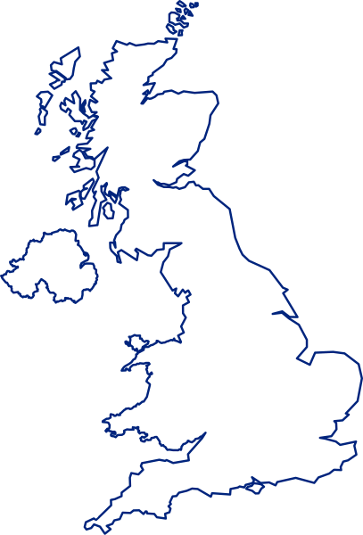
English: A map of the United Kingdom, overlaid with the UK flag.
Русский: Флаг-карта Соединённого Королевства |
||
| Dîrok | |||
| Çavkanî | Min çêkir | ||
| Xwedî | Inductiveload | ||
| Destûr (Dîsa bikaranînê vê dosyeye) |
|
||
| Guhartoyên din |
 |
||
| SVG genesis |
Dîroka daneyê
Ji bo dîtina guhartoya wê demê bişkoka dîrokê bitikîne.
| Dîrok/Katjimêr | Wêneyê biçûk | Mezinahî | Bikarhêner | Şirove | |
|---|---|---|---|---|---|
| niha | 15:14, 24 tîrmeh 2021 | | 661 x 974 (109 KB) | GPinkerton | Improve flag geometry, remove Isle of Man (not strictly part of the UK). Shetland (definitely a part) still missing ... |
| 20:40, 10 kanûna paşîn 2015 |  | 720 x 1000 (130 KB) | AnonMoos | Reverted to version as of 09:28, 15 January 2012 -- unfortunately, the new upload is less clear when displayed at a small size, and filesize was bloated over 1000% | |
| 16:03, 9 kanûna paşîn 2015 |  | 419 x 750 (1,71 MB) | Stasyan117 | border and islands | |
| 09:28, 15 kanûna paşîn 2012 |  | 720 x 1000 (130 KB) | Gajmar | Blue borders | |
| 19:33, 3 sibat 2008 |  | 720 x 1000 (129 KB) | Inductiveload | fix white fill on borders | |
| 19:23, 3 sibat 2008 |  | 720 x 1000 (100 KB) | Inductiveload | {{Information |Description=A map of the United Kingdom, overlaid with the UK flag. |Source=self-made |Date=03/02/2008 |Author= Inductiveload |Permission={{PD-self}} |other_versions= }} Category:Maps of the United Kingdom |
Bikaranîna pelê
Zêdetirî 100 rûpelan vê pelê bi kar tînin. Lîsteya li jêr 100 rûpelên pêşîn ên ku tenê vê rûpelê bi kar tînin nîşan dide. Lîsteya temamê wan berdest e.
- Aberdeen
- Armagh
- Bangor
- Bath, Somerset
- Belfast
- Berkshire
- Birmingham
- Bradford
- Brighton and Hove
- Bristol
- Cambridge
- Canterbury
- Cardiff
- Carlisle
- Chelmsford
- Chester
- Chichester
- City of Bradford
- City of Canterbury
- City of Carlisle
- City of Chelmsford
- City of Lancaster
- City of Leeds
- City of London
- City of Preston
- City of Salford
- City of Sheffield
- City of Sunderland
- City of Wakefield
- City of Westminster
- City of Winchester
- Cornwall
- Coventry
- Cumberland
- Derby
- Derry
- Devon
- Dorset
- Dundee
- Durham
- Edinburgh
- Ely, Cambridgeshire
- Essex
- Exeter
- Glamorgan
- Glasgow
- Gloucester
- Hampshire
- Hastings
- Hereford
- Inverness
- Kent
- Kingston upon Hull
- Lancashire
- Leeds
- Leicester
- Lichfield
- Lincoln (Lincolnshire)
- Lisburn
- Liverpool
- Manchester
- Newcastle upon Tyne
- Newport, Monmouthshire
- Newport, Pembrokeshire
- Newry
- Norfolk
- Northumberland
- Norwich
- Nottingham
- Perth, Skotlenda
- Peterborough
- Plymouth
- Portsmouth
- Preston
- Ripon
- Rutland
- Saint Albans
- Saint Albans City and District
- Saint Asaph
- Saint Davids
- Salford
- Salisbury
- Sheffield
- Somerset
- Southampton
- Stirling
- Stoke-on-Trent
- Suffolk
- Sunderland
- Surrey
- Swansea
- Truro
- Wakefield
- Wells
- Westmorland
- Wiltshire
- Winchester
- Wolverhampton
- Worcester
- York
View more links to this file.
Bikaranîna gerdûnî ya pelê
Ev wîkiyên di rêzê de vê pelê bi kar tînin:
- Bikaranîna di ace.wikipedia.org de
- Bikaranîna di ar.wikipedia.org de
- غرينتش
- جزر الأنتيل الكبرى
- غيرنزي
- قائمة مدن المملكة المتحدة
- خط الطول الأول (غرينتش)
- إكسمنستر
- جزر كايمان
- ويكيبيديا:صناديق المستخدم/بلدان
- دمبارتون
- شابينساي
- سان بيتر بورت
- بروفيدنسياليس
- جزيرة الطيور (المملكة المتحدة)
- سندرلاند
- بيليمينا
- تورفين
- تلة كليف
- الجمعية الجغرافية الملكية
- لوستويزيل
- نهر فاوي
- بولستيد
- كادسدن
- إنفرنيس
- أسكوت
- سالفورد
- وايت تشابل
- هارلو
- توتون
- دوكنج (نورفولك)
- سودرك
- هامرسميث
- لافيونا
- إيلي (كامبريدجشير)
- برايتون أند هوف
- تشيلمسفورد (إسكس)
- تشيتشستر
- ريبون (شمال يوركشير)
- مدينة ولز (إنجلترا)
- خليج ماساشوستس
- مستخدم:Sylvia Ford
- دونكاستر
- ويندرمير (كمبريا)
- ويندرمير
- وايتستابل
- ساوث سي
- لوثيان الشرقية
- آلدرني
- شوريهام
Zêdetir bikaranîna global a vê pelê bibîne.