Wêne:Ternate (City), Indonesia (2010).jpg

Mezinahiya vê pêşdîtinê: 800 × 600 pîksel. Resolusyonên din: 320 × 240 pîksel | 640 × 480 pîksel | 1024 × 768 pîksel | 1280 × 960 pîksel | 2560 × 1920 pîksel | 4000 × 3000 pîksel.
Dosyeya orjînal (4000 × 3000 pixel, mezinbûnê data: 2,76 MB, MIME-typ: image/jpeg)
| Ev pel ji Wikimedia Commonsê ye. Agahdariya li ser rûpela danasîna pelê li jêr tê nîşandan. |
,_Indonesia_(2010).jpg?uselang=ku-latn)
Danasîn
| Danasîn |
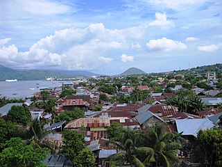
Deutsch: Kota Ternate Richtung Süden. Im Hintergrund der 1730 Meter hohe Vulkan Keimatubu der Nachbarinsel Tidore. Aufnahme durch den US-Diplomaten Tom Weinz nach der Ankunft des Hospitalsschiffs USNS Mercy im Rahmen der Pacific Partnership 2010 in Ternate.
English: Ternate City, located on the island of the same name, is the former administrative centre of North Maluku Province, Indonesia. U.S. Foreign Service Liaison Officer Tom Weinz captures a photo as the USNS Mercy for Pacific Partnership 2010 arrives in Ternate, Indonesia, on July 18, 2010.
Français : Ternate City, sur l'île de Ternate, est l'ancien centre administratif de la province des Moluques du Nord. |
| Dîrok | |
| Çavkanî | https://www.flickr.com/photos/statephotos/4811774905/ |
| Xwedî | U.S. Foreign Service Liaison Officer Tom Weinz |
| Guhartoyên din |
| Şûnda kamerayê | | Ev wêne û yên din li ser OpenStreetMap |
|---|
,_Indonesia_(2010).jpg¶ms=000.813475_N_0127.388278_E_globe:Earth_type:camera_region:ID_heading:180.00&language=ku)
Lîsans
| This image is a work of a United States Department of State employee, taken or made as part of that person's official duties. As a work of the U.S. federal government, the image is in the public domain per 17 U.S.C. § 101 and § 105 and the Department Copyright Information. |  |
| This image was originally posted to Flickr by U.S. Department of State at https://flickr.com/photos/9364837@N06/4811774905. It was reviewed on 16 tebax 2017 by FlickreviewR and was confirmed to be licensed under the terms of the United States Government Work. |

|
This image has been assessed under the valued image criteria and is considered the most valued image on Commons within the scope: Ternate City, Indonesia. You can see its nomination here. |
,_Indonesia_(2010).jpg)
Dîroka daneyê
Ji bo dîtina guhartoya wê demê bişkoka dîrokê bitikîne.
| Dîrok/Katjimêr | Wêneyê biçûk | Mezinahî | Bikarhêner | Şirove | |
|---|---|---|---|---|---|
| niha | 16:44, 1 tebax 2010 | | 4000 x 3000 (2,76 MB) | Wikifreund | {{Information |Description=U.S. Foreign Service Liaison Officer Tom Weinz captures a photo as the USNS Mercy for Pacific Partnership 2010 arrives in Ternate, Indonesia, on July 18, 2010. |Source=http://www.flickr.com/photos/statephotos/4811774905/ |Date=2 |
Bikaranîna pelê
Ev rûpelên li jêr vê dosyeyê bi kar tînin:
Bikaranîna gerdûnî ya pelê
Ev wîkiyên di rêzê de vê pelê bi kar tînin:
- Bikaranîna di ar.wikipedia.org de
- Bikaranîna di ceb.wikipedia.org de
- Bikaranîna di ce.wikipedia.org de
- Bikaranîna di de.wikipedia.org de
- Bikaranîna di en.wikivoyage.org de
- Bikaranîna di eo.wikipedia.org de
- Bikaranîna di et.wikipedia.org de
- Bikaranîna di he.wikipedia.org de
- Bikaranîna di he.wikiquote.org de
- Bikaranîna di id.wikipedia.org de
- Bikaranîna di incubator.wikimedia.org de
- Bikaranîna di ja.wikipedia.org de
- Bikaranîna di ko.wikipedia.org de
- Bikaranîna di lt.wikipedia.org de
- Bikaranîna di min.wikipedia.org de
- Bikaranîna di ml.wikipedia.org de
- Bikaranîna di nl.wikipedia.org de
- Bikaranîna di pl.wikipedia.org de
- Bikaranîna di pl.wikivoyage.org de
- Bikaranîna di ru.wikipedia.org de
- Bikaranîna di sv.wikipedia.org de
- Bikaranîna di tay.wikipedia.org de
- Bikaranîna di tt.wikipedia.org de
- Bikaranîna di uk.wikipedia.org de
- Bikaranîna di www.wikidata.org de
- Bikaranîna di zh.wikipedia.org de
,_Indonesia_(2010).jpg)