Wêne:Soviet caucasus1922.png

Mezinahiya vê pêşdîtinê: 800 × 571 pîksel. Resolusyonên din: 320 × 229 pîksel | 640 × 457 pîksel | 1024 × 731 pîksel | 1280 × 914 pîksel | 1613 × 1152 pîksel.
Dosyeya orjînal (1613 × 1152 pixel, mezinbûnê data: 127 KB, MIME-typ: image/png)
| Ev pel ji Wikimedia Commonsê ye. Agahdariya li ser rûpela danasîna pelê li jêr tê nîşandan. |
Danasîn
| Danasîn |
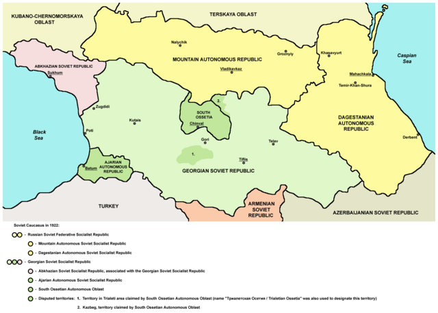
English: Northern part of Soviet Caucasus in 1922 - Mountain Autonomous Soviet Socialist Republic, Dagestanian Autonomous Soviet Socialist Republic, Georgian Soviet Socialist Republic, Abkhazian Soviet Socialist Republic, Ajarian Autonomous Soviet Socialist Republic, South Ossetian Autonomous Oblast and disputed territories claimed by South Ossetian Autonomous Oblast (Trialeti area / Trialetian Ossetia and Kazbeg). |
| Dîrok | |
| Çavkanî | Min çêkir |
| Xwedî | PANONIAN |
| Guhartoyên din |
|

Lîsans
| I, the copyright holder of this work, release this work into the public domain. This applies worldwide. In some countries this may not be legally possible; if so: I grant anyone the right to use this work for any purpose, without any conditions, unless such conditions are required by law. |
References
Made according to these sources:
- http://www.iriston.com/books/cuciev_-_etno_atlas/cuciev_etno-polit_map.htm - 50 maps from book "АТЛАС ЭТНОПОЛИТИЧЕСКОЙ ИСТОРИИ КАВКАЗА", Цуциев А.А, Москва: Издательство «Европа», 2007. ("Atlas of ethnopolitical history of Caucasus", Tsutsiev A.A, Moscow: Publisher «Evropa», 2007), inluding a map of Soviet Caucasus in 1921, which show Mountain Autonomous Soviet Socialist Republic, Dagestanian Autonomous Soviet Socialist Republic, Georgian Soviet Socialist Republic, Abkhazian Soviet Socialist Republic, Ajarian Autonomous Soviet Socialist Republic, and disputed territories inhabited by Ossetians: South Ossetia, Trialetian Ossetia and Kazbeg.
- http://dic.academic.ru/pictures/wiki/files/84/Tsutsiev.jpg - map from book "АТЛАС ЭТНОПОЛИТИЧЕСКОЙ ИСТОРИИ КАВКАЗА", Цуциев А.А ("Atlas of ethnopolitical history of Caucasus", Tsutsiev A.A), inluding a map of Soviet Caucasus in 1921, which show Mountain Autonomous Soviet Socialist Republic, Dagestanian Autonomous Soviet Socialist Republic, Georgian Soviet Socialist Republic, Abkhazian Soviet Socialist Republic, Ajarian Autonomous Soviet Socialist Republic, and disputed territories inhabited by Ossetians: South Ossetia, Trialetian Ossetia and Kazbeg.
- http://www.iriston.com/nogbon/pictures/Tabol/cuciev_karta_6.jpg - map of Soviet Caucasus in 1922, created by Tsutsiev A.A, which show Mountain Autonomous Soviet Socialist Republic and South Ossetian Autonomous Oblast.
Dîroka daneyê
Ji bo dîtina guhartoya wê demê bişkoka dîrokê bitikîne.
| Dîrok/Katjimêr | Wêneyê biçûk | Mezinahî | Bikarhêner | Şirove | |
|---|---|---|---|---|---|
| niha | 17:03, 26 kanûna pêşîn 2015 | | 1613 x 1152 (127 KB) | PANONIAN | Reverted to version as of 14:47, 27 March 2010 (UTC) - please upload your version under different filename |
| 10:56, 26 kanûna pêşîn 2015 |  | 1613 x 1090 (115 KB) | Ercwlff | corrected georgian city names | |
| 10:45, 26 kanûna pêşîn 2015 |  | 1613 x 1090 (114 KB) | Ercwlff | corrected | |
| 10:42, 26 kanûna pêşîn 2015 |  | 1613 x 1090 (117 KB) | Ercwlff | ~~~~ | |
| 14:47, 27 adar 2010 |  | 1613 x 1152 (127 KB) | PANONIAN | on the second thought, this map is focused on the history of Ossetians and other north Caucasian peoples and therefore disputes areas claimed by Armenia and Azerbaijan are not very relevant subject here | |
| 22:04, 26 adar 2010 |  | 1613 x 1216 (134 KB) | PANONIAN | corrected one description | |
| 22:54, 25 adar 2010 |  | 1613 x 1216 (132 KB) | PANONIAN | new version | |
| 23:52, 23 adar 2010 |  | 1613 x 1122 (121 KB) | PANONIAN | correction | |
| 18:51, 23 adar 2010 |  | 1613 x 1122 (121 KB) | PANONIAN | significant improvement - I hope that this is a final version | |
| 16:32, 23 adar 2010 |  | 1227 x 915 (88 KB) | PANONIAN | corrections |
Bikaranîna pelê
Ev rûpelên li jêr vê dosyeyê bi kar tînin:
Bikaranîna gerdûnî ya pelê
Ev wîkiyên di rêzê de vê pelê bi kar tînin:
- Bikaranîna di ar.wikipedia.org de
- Bikaranîna di ast.wikipedia.org de
- Bikaranîna di bg.wikipedia.org de
- Bikaranîna di bn.wikipedia.org de
- Bikaranîna di br.wikipedia.org de
- Bikaranîna di ca.wikipedia.org de
- Bikaranîna di ce.wikipedia.org de
- Bikaranîna di de.wikipedia.org de
- Bikaranîna di en.wikipedia.org de
- Bikaranîna di eo.wikipedia.org de
- Bikaranîna di es.wikipedia.org de
- Bikaranîna di et.wikipedia.org de
- Bikaranîna di fi.wikipedia.org de
- Bikaranîna di fr.wikipedia.org de
- Bikaranîna di it.wikipedia.org de
- Bikaranîna di ja.wikipedia.org de
- Bikaranîna di kk.wikipedia.org de
- Bikaranîna di ko.wikipedia.org de
- Bikaranîna di lt.wikipedia.org de
- Bikaranîna di lv.wikipedia.org de
- Bikaranîna di mk.wikipedia.org de
- Bikaranîna di no.wikipedia.org de
- Bikaranîna di os.wikipedia.org de
- Bikaranîna di pl.wikipedia.org de
Zêdetir bikaranîna global a vê pelê bibîne.