Wêne:SonghuaRiver ASTER 20020401.jpg

Mezinahiya vê pêşdîtinê: 466 × 600 pîksel. Resolusyonên din: 186 × 240 pîksel | 373 × 480 pîksel | 597 × 768 pîksel | 796 × 1024 pîksel | 2124 × 2733 pîksel.
Dosyeya orjînal (2124 × 2733 pixel, mezinbûnê data: 1,82 MB, MIME-typ: image/jpeg)
| Ev pel ji Wikimedia Commonsê ye. Agahdariya li ser rûpela danasîna pelê li jêr tê nîşandan. |
Danasîn
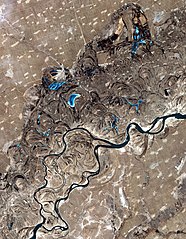
| Danasîn | Satellite photo of the w:Songhua River, just west of Harbin, northeast China. |
| Dîrok | |
| Çavkanî | http://earthobservatory.nasa.gov/Newsroom/NewImages/images.php3?img_id=17135 |
| Xwedî | NASA/GSFC/METI/ERSDAC/JAROS, and the U.S./Japan ASTER Science Team. |
| Destûr (Dîsa bikaranînê vê dosyeye) |
US government, public domain |
Lîsans
| This file is in the public domain in the United States because it was solely created by NASA. NASA copyright policy states that "NASA material is not protected by copyright unless noted". (See Template:PD-USGov, NASA copyright policy page or JPL Image Use Policy.) | ||
 |
Warnings:
|
Dîroka daneyê
Ji bo dîtina guhartoya wê demê bişkoka dîrokê bitikîne.
| Dîrok/Katjimêr | Wêneyê biçûk | Mezinahî | Bikarhêner | Şirove | |
|---|---|---|---|---|---|
| niha | 17:53, 1 gulan 2006 | | 2124 x 2733 (1,82 MB) | Holly Cheng | {{Information | Description=Satellite photo of the w:Songhua River, northeast China. | Source=http://earthobservatory.nasa.gov/Newsroom/NewImages/images.php3?img_id=17135 | Date=April 1, 2002 | Author=NASA/GSFC/METI/ERSDAC/JAROS, and the U.S./Japan AS |
Bikaranîna pelê
Ev rûpelên li jêr vê dosyeyê bi kar tînin:
Bikaranîna gerdûnî ya pelê
Ev wîkiyên di rêzê de vê pelê bi kar tînin:
- Bikaranîna di af.wikipedia.org de
- Bikaranîna di ar.wikipedia.org de
- Bikaranîna di arz.wikipedia.org de
- Bikaranîna di ast.wikipedia.org de
- Bikaranîna di az.wikipedia.org de
- Bikaranîna di be-tarask.wikipedia.org de
- Bikaranîna di be.wikipedia.org de
- Bikaranîna di bn.wikipedia.org de
- Bikaranîna di ca.wikipedia.org de
- Bikaranîna di ceb.wikipedia.org de
- Bikaranîna di ce.wikipedia.org de
- Bikaranîna di ckb.wikipedia.org de
- Bikaranîna di cs.wikipedia.org de
- Bikaranîna di cv.wikipedia.org de
- Bikaranîna di cy.wikipedia.org de
- Bikaranîna di de.wikipedia.org de
- Bikaranîna di de.wikivoyage.org de
- Bikaranîna di en.wikipedia.org de
- Bikaranîna di eo.wikipedia.org de
- Bikaranîna di es.wikipedia.org de
- Bikaranîna di et.wikipedia.org de
- Bikaranîna di eu.wikipedia.org de
- Bikaranîna di fa.wikipedia.org de
- Bikaranîna di fi.wikipedia.org de
- Bikaranîna di fr.wikipedia.org de
- Bikaranîna di fr.wikivoyage.org de
- Bikaranîna di ga.wikipedia.org de
- Bikaranîna di gl.wikipedia.org de
- Bikaranîna di hy.wikipedia.org de
- Bikaranîna di ia.wikipedia.org de
Zêdetir bikaranîna global a vê pelê bibîne.