Wêne:Snow in Coastal North Carolina 2010-02-14.jpg

Mezinahiya vê pêşdîtinê: 600 × 600 pîksel. Resolusyonên din: 240 × 240 pîksel | 480 × 480 pîksel | 720 × 720 pîksel.
Dosyeya orjînal (720 × 720 pixel, mezinbûnê data: 455 KB, MIME-typ: image/jpeg)
| Ev pel ji Wikimedia Commonsê ye. Agahdariya li ser rûpela danasîna pelê li jêr tê nîşandan. |
Danasîn
| Danasîn |
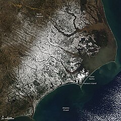
English: With miles of sandy beaches and generally good weather, coastal North Carolina isn’t a place you would usually expect to find snow. But the view from the Moderate Resolution Imaging Spectroradiometer (MODIS) on NASA’s Aqua satellite on February 14, 2010, shows snow extending to the Outer Banks. The sandy islands, normally pale tan, are bright white in this image. Harkers Island received 8.8 inches of snow, reported CNN. The snow fell in a winter storm that moved across the southern United States from Texas to the Atlantic Coast on February 12-13. |
| Dîrok | |
| Çavkanî | http://earthobservatory.nasa.gov/NaturalHazards/view.php?id=42698&src=nha |
| Xwedî | NASA |
| Guhartoyên din |
|

Lîsans
| This file is in the public domain in the United States because it was solely created by NASA. NASA copyright policy states that "NASA material is not protected by copyright unless noted". (See Template:PD-USGov, NASA copyright policy page or JPL Image Use Policy.) | ||
 |
Warnings:
|
Dîroka daneyê
Ji bo dîtina guhartoya wê demê bişkoka dîrokê bitikîne.
| Dîrok/Katjimêr | Wêneyê biçûk | Mezinahî | Bikarhêner | Şirove | |
|---|---|---|---|---|---|
| niha | 19:42, 16 sibat 2010 | | 720 x 720 (455 KB) | Captain-tucker | {{Information |Description={{en|With miles of sandy beaches and generally good weather, coastal North Carolina isn’t a place you would usually expect to find snow. But the view from the Moderate Resolution Imaging Spectroradiometer (MODIS) on NASA’s A |
Bikaranîna pelê
Ev rûpelên li jêr vê dosyeyê bi kar tînin:
Bikaranîna gerdûnî ya pelê
Ev wîkiyên di rêzê de vê pelê bi kar tînin:
- Bikaranîna di ar.wikipedia.org de
- Bikaranîna di ary.wikipedia.org de
- Bikaranîna di arz.wikipedia.org de
- Bikaranîna di ast.wikipedia.org de
- Bikaranîna di ca.wikipedia.org de
- Bikaranîna di cy.wikipedia.org de
- Bikaranîna di dag.wikipedia.org de
- Bikaranîna di de.wikivoyage.org de
- Bikaranîna di diq.wikipedia.org de
- Bikaranîna di eo.wikipedia.org de
- Bikaranîna di eu.wikipedia.org de
- Bikaranîna di fr.wikinews.org de
- Bikaranîna di fr.wikivoyage.org de
- Bikaranîna di ga.wikipedia.org de
- Bikaranîna di gl.wikipedia.org de
- Bikaranîna di ha.wikipedia.org de
- Bikaranîna di he.wikipedia.org de
- Bikaranîna di ht.wikipedia.org de
- Bikaranîna di hy.wikipedia.org de
- Bikaranîna di ia.wikipedia.org de
- Bikaranîna di ig.wikipedia.org de
- Bikaranîna di mhr.wikipedia.org de
- Bikaranîna di nn.wikipedia.org de
- Bikaranîna di oc.wikipedia.org de
- Bikaranîna di os.wikipedia.org de
- Bikaranîna di pap.wikipedia.org de
- Bikaranîna di pl.wikipedia.org de
- Bikaranîna di ru.wikinews.org de
- Bikaranîna di sr.wikipedia.org de
- Bikaranîna di tg.wikipedia.org de
- Bikaranîna di tl.wikipedia.org de
- Bikaranîna di tt.wikipedia.org de
- Bikaranîna di vec.wikipedia.org de
- Bikaranîna di vi.wikipedia.org de
- Bikaranîna di www.wikidata.org de