Wêne:Map-of-Ottoman-Empire-in-1900-German.svg

Size of this PNG preview of this SVG file: 800 × 502 pîksel. Resolusyonên din: 320 × 201 pîksel | 640 × 401 pîksel | 1024 × 642 pîksel | 1280 × 803 pîksel | 2560 × 1605 pîksel | 2647 × 1660 pîksel.
Dosyeya orjînal (Daneya SVG, mezinbûna rast: 2647 × 1660 pixel; mezinbûna daneyê: 82 KB)
| Ev pel ji Wikimedia Commonsê ye. Agahdariya li ser rûpela danasîna pelê li jêr tê nîşandan. |
| Danasîn |
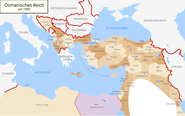
Deutsch: Karte des Osmanischen Reiches um 1900 in Deutsch
English: Map of Ottoman Empire (1900) in German |
| Dîrok | (UTC) |
| Çavkanî | |
| Xwedî |
|
| Guhartoyên din |
Map-of-Ottoman-Empire-in-1900-German.svg[]
Derivative works of this file: |


.svg)
.jpg)
I, the copyright holder of this work, hereby publish it under the following license:
| I, the copyright holder of this work, release this work into the public domain. This applies worldwide. In some countries this may not be legally possible; if so: I grant anyone the right to use this work for any purpose, without any conditions, unless such conditions are required by law. |
Original upload log
This image is a derivative work of the following images:
- File:Map-of-Ottoman-Empire-in-1900-Latvian.svg licensed with PD-self
- 2008-01-30T21:53:09Z Juristiltins 885x557 (105823 Bytes) {{Information |Description=Map of Ottoman Empire (1900) in Latvian |Source=own work |Date=30 January 2008 |Author=Juris Tiltins |Permission=Free use and distribution permitted. |other_versions= }} [[Category:Maps of the Ottom
Uploaded with derivativeFX
Dîroka daneyê
Ji bo dîtina guhartoya wê demê bişkoka dîrokê bitikîne.
| Dîrok/Katjimêr | Wêneyê biçûk | Mezinahî | Bikarhêner | Şirove | |
|---|---|---|---|---|---|
| niha | 09:25, 18 gulan 2018 | | 2647 x 1660 (82 KB) | NordNordWest | corr |
| 16:03, 15 îlon 2010 |  | 2647 x 1660 (79 KB) | NordNordWest | c | |
| 16:01, 15 îlon 2010 |  | 2646 x 1660 (79 KB) | NordNordWest | c | |
| 16:00, 15 îlon 2010 |  | 2646 x 1660 (79 KB) | NordNordWest | c | |
| 18:30, 28 tebax 2010 |  | 2645 x 1661 (112 KB) | NordNordWest | bigger | |
| 18:18, 28 tebax 2010 |  | 885 x 557 (96 KB) | NordNordWest | {{Information |Description={{de|Karte des Osmanischen Reiches um 1900 in Deutsch}} {{en|Map of Ottoman Empire (1900) in German}} |Source=*File:Map-of-Ottoman-Empire-in-1900-Latvian.svg |Date=2010-08-28 18:18 (UTC) |Author=*[[:File:Map-of-Ottoman-Emp |
Bikaranîna pelê
Rûpelekî ku ji vê dosyeyê bi kar tîne nîne.
Bikaranîna gerdûnî ya pelê
Ev wîkiyên di rêzê de vê pelê bi kar tînin:
- Bikaranîna di af.wikipedia.org de
- Bikaranîna di als.wikipedia.org de
- Bikaranîna di cy.wikipedia.org de
- Bikaranîna di de.wikipedia.org de
- Bikaranîna di en.wikipedia.org de
- Bikaranîna di he.wikipedia.org de
- Bikaranîna di it.wikipedia.org de
- Bikaranîna di lv.wikipedia.org de
- Bikaranîna di no.wikipedia.org de
- Bikaranîna di pl.wikipedia.org de
- Bikaranîna di pnb.wikipedia.org de
- Bikaranîna di ru.wikipedia.org de
- Bikaranîna di sk.wikipedia.org de
- Bikaranîna di sr.wikipedia.org de
- Bikaranîna di sv.wikipedia.org de
- Bikaranîna di tr.wikipedia.org de
- Bikaranîna di ur.wikipedia.org de