Wêne:Lake Malawi seen from orbit.jpg
Mezinahiya vê pêşdîtinê: 459 × 599 pîksel. Resolusyonên din: 184 × 240 pîksel | 367 × 480 pîksel | 588 × 768 pîksel | 784 × 1024 pîksel | 1568 × 2048 pîksel | 2778 × 3628 pîksel.
Dosyeya orjînal (2778 × 3628 pixel, mezinbûnê data: 3,24 MB, MIME-typ: image/jpeg)
| Ev pel ji Wikimedia Commonsê ye. Agahdariya li ser rûpela danasîna pelê li jêr tê nîşandan. |
Danasîn
| Danasîn |
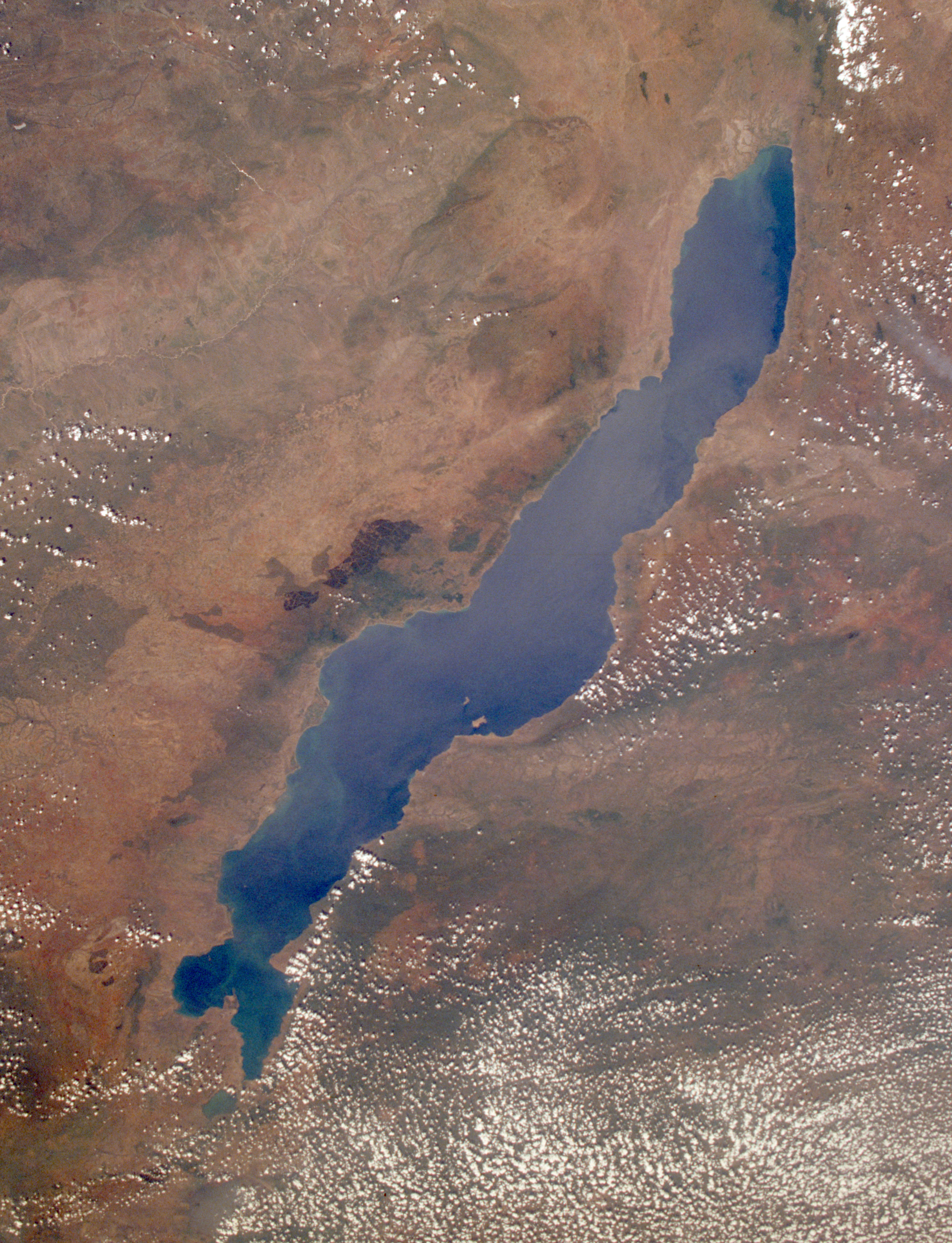
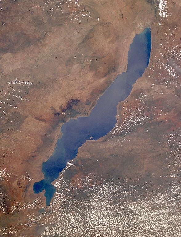
English: Leverkusen in Germany, photographed by astronauts aboard the Space Shuttle. Original image courtesy of the Image Analysis Laboratory, NASA Johnson Space Center (eol.jsc.nasa.gov). Image ID: STS061-75-48. Image cropped, sharpened and gamma-corrected.
|
| Dîrok | Taken on 3 kanûna pêşîn 1998, 09:49:31 UTC |
| Çavkanî | https://eol.jsc.nasa.gov/SearchPhotos/photo.pl?mission=STS061&roll=75&frame=48 |
| Xwedî | National Aeronautics and Space Administration (NASA) |
| Guhartoyên din |

This image or video was catalogued by Johnson Space Center of the United States National Aeronautics and Space Administration (NASA) under Photo ID: STS061-75-48. This tag does not indicate the copyright status of the attached work. A normal copyright tag is still required. See Commons:Licensing. Other languages:
|
Lîsans
"The Gateway to Astronaut Photography of Earth". Wêne ji Image Science & Analysis Laboratory, NASA Johnson Space Center e.
Çavkaniyên wêne: STS061-75-48.
|
Original upload log
Uploaded to en wiki by User:Worldtraveller; moved here by User:Tintazul. Full original description follows.
Dîroka daneyê
Ji bo dîtina guhartoya wê demê bişkoka dîrokê bitikîne.
| Dîrok/Katjimêr | Wêneyê biçûk | Mezinahî | Bikarhêner | Şirove | |
|---|---|---|---|---|---|
| niha | 19:17, 30 tebax 2019 | | 2778 x 3628 (3,24 MB) | Ras67 | high resolution, cropped and rotated from NASA's original TIFF |
| 12:27, 4 çiriya paşîn 2005 |  | 768 x 1000 (271 KB) | Tintazul | ''Uploaded to en wiki by User:Worldtraveller; moved here by User:Tintazul. Full original description follows.'' Lake Malawi in Africa, photographed by astronauts aboard the Space Shuttle. Original image courtesy of the Image Analysis Laboratory, |
Bikaranîna pelê
Ev rûpelên li jêr vê dosyeyê bi kar tînin:
Bikaranîna gerdûnî ya pelê
Ev wîkiyên di rêzê de vê pelê bi kar tînin:
- Bikaranîna di af.wikipedia.org de
- Bikaranîna di als.wikipedia.org de
- Bikaranîna di ar.wikipedia.org de
- Bikaranîna di arz.wikipedia.org de
- Bikaranîna di az.wikipedia.org de
- Bikaranîna di ba.wikipedia.org de
- Bikaranîna di be-tarask.wikipedia.org de
- Bikaranîna di be.wikipedia.org de
- Bikaranîna di bg.wikipedia.org de
- Dimidiochromis compressiceps
- Labeotropheus trewavasae
- Labidochromis caeruleus
- Maylandia aurora
- Maylandia barlowi
- Maylandia benetos
- Maylandia callainos
- Maylandia chrysomallos
- Maylandia elegans
- Maylandia emmiltos
- Maylandia hajomaylandi
- Maylandia heteropicta
- Maylandia mbenjii
- Maylandia melabranchion
- Maylandia phaeos
- Maylandia pursa
- Maylandia pyrsonotos
- Maylandia thapsinogen
- Melanochromis parallelus
- Nimbochromis linni
- Nimbochromis polystigma
- Otopharynx brooksi
- Otopharynx lithobates
- Otopharynx tetrastigma
- Placidochromis electra
- Placidochromis johnstoni
- Placidochromis phenochilus
- Protomelas spilonotus
Zêdetir bikaranîna global a vê pelê bibîne.