Wêne:Persian(IRAN) Empire 1747.jpg
Mezinahiya vê pêşdîtinê: 715 × 600 pîksel. Resolusyonên din: 286 × 240 pîksel | 572 × 480 pîksel | 915 × 768 pîksel | 1220 × 1024 pîksel | 2441 × 2048 pîksel | 5420 × 4548 pîksel.
Dosyeya orjînal (5420 × 4548 pixel, mezinbûnê data: 8,38 MB, MIME-typ: image/jpeg)
| Ev pel ji Wikimedia Commonsê ye. Agahdariya li ser rûpela danasîna pelê li jêr tê nîşandan. |
Danasîn
| Danasîn |
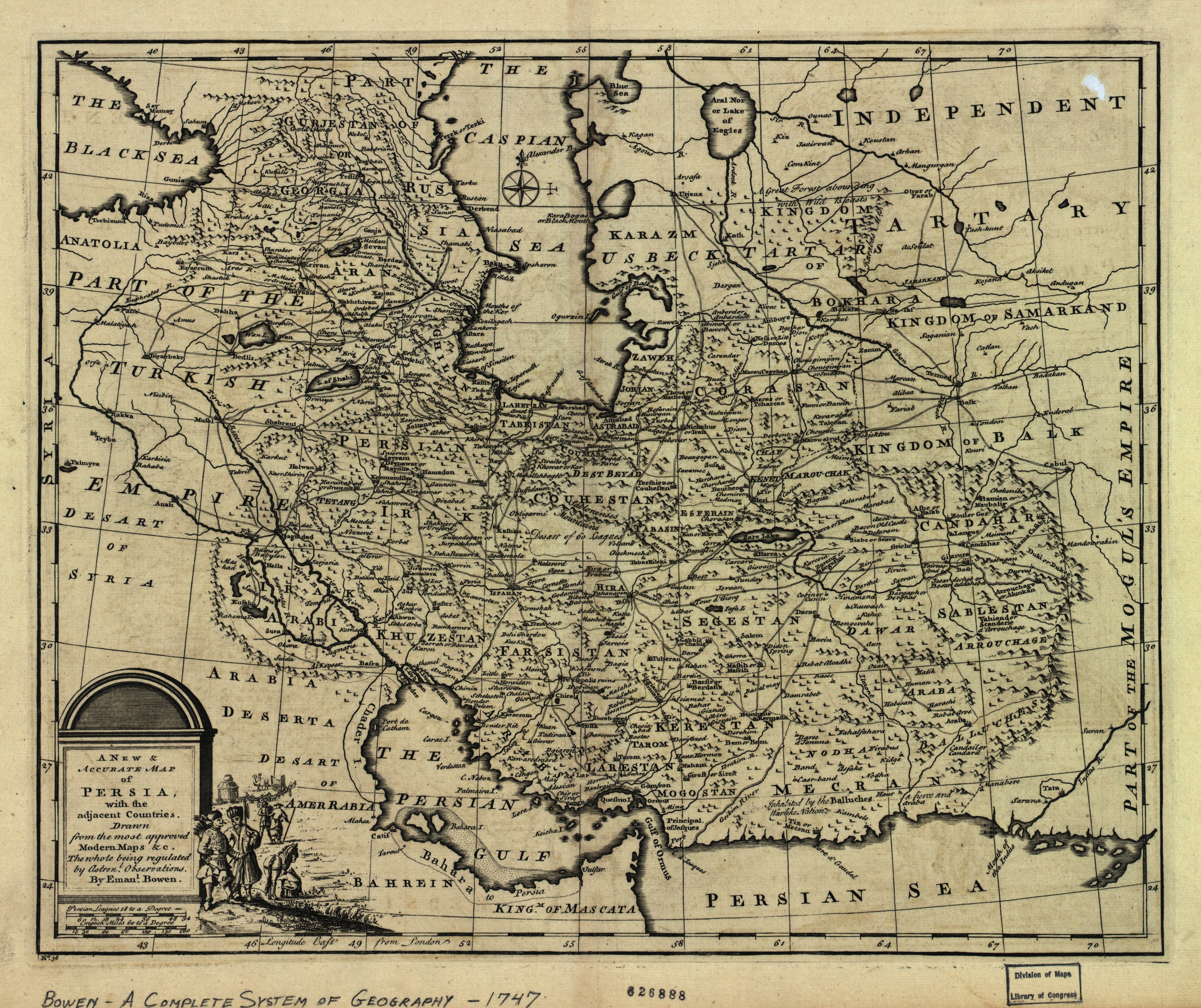
English: The map of the Persian Empire in 1747 at the time of Afsharid Dynasty. a complete system of geography.
فارسی: نقشهٔ امپراطوری ایران در سال ۱۷۴۷ میلادی برابر با ۱۱۲۶ خورشیدی و ۱۱۶۰ قمری در زمان دودمان افشاریان |
|||||||||||||||||||||||
| Dîrok | circa 1750 | |||||||||||||||||||||||
| Çavkanî | http://memory.loc.gov/ | |||||||||||||||||||||||
| Xwedî |
|
|||||||||||||||||||||||
| Guhartoyên din |
Derivative works of this file: |
|||||||||||||||||||||||

_Empire_1747.jpg?uselang=ku-latn)
_Empire_1747_(A).JPG)
_Empire_1747_(B).JPG)
|
_Empire_1747.jpg)
Lîsans
|
This is a faithful photographic reproduction of a two-dimensional, public domain work of art. The work of art itself is in the public domain for the following reason:
The official position taken by the Wikimedia Foundation is that "faithful reproductions of two-dimensional public domain works of art are public domain".
This photographic reproduction is therefore also considered to be in the public domain in the United States. In other jurisdictions, re-use of this content may be restricted; see Reuse of PD-Art photographs for details. | ||||
Dîroka daneyê
Ji bo dîtina guhartoya wê demê bişkoka dîrokê bitikîne.
| Dîrok/Katjimêr | Wêneyê biçûk | Mezinahî | Bikarhêner | Şirove | |
|---|---|---|---|---|---|
| niha | 18:21, 9 tîrmeh 2012 | | 5420 x 4548 (8,38 MB) | Paris 16 | e |
| 15:40, 31 tebax 2008 |  | 5664 x 4715 (7,22 MB) | Wayiran | {{Information |Description={{en|1=The map of the Persian Empire in 1747 at the time of Afsharid Dynasty}} {{fa|1=نقشهٔ امپراطوری ایران در سال ۱۷۴۷ میلادی برابر با ۱۱۲۶ خورشیدی و ۱۱۶۰ قمری در � |
Bikaranîna pelê
Ev rûpelên li jêr vê dosyeyê bi kar tînin:
Bikaranîna gerdûnî ya pelê
Ev wîkiyên di rêzê de vê pelê bi kar tînin:
- Bikaranîna di azb.wikipedia.org de
- Bikaranîna di ckb.wikipedia.org de
- Bikaranîna di de.wikipedia.org de
- Bikaranîna di diq.wikipedia.org de
- Bikaranîna di en.wikipedia.org de
- Bikaranîna di eo.wikipedia.org de
- Bikaranîna di et.wikipedia.org de
- Bikaranîna di fa.wikipedia.org de
- دریای عمان
- خلیج فارس
- مشهد
- تاریخ ایران
- نادرشاه
- شهرستان میانه
- میانه (آذربایجان شرقی)
- ایران بزرگ
- ایران افشاری
- آذربایجان
- نقشهنگاری
- تاریخ ارمنستان
- تحریف نام خلیج فارس
- جغرافیای تاریخی ایران
- ویکیپدیا:گزیدن نگاره برگزیده/دسامبر-۲۰۱۱
- ویکیپدیا:نگارههای برگزیده/نقشه
- ویکیپدیا:نگاره روز/آوریل ۲۰۱۲
- نقشه ایران در دوره افشاریه
- ویکیپدیا:گزیدن نگاره برگزیده/Persian(IRAN) Empire 1747.jpg
- الگو:نر/2012-04-06
- بحث کاربر:Alborzagros/بایگانی ۴
- الگو:نر محافظت شده/2012-04-06
- نقشههای کهن
- ارمنستان ایران (۱۵۰۲–۱۸۲۸)
- فهرست سلسلههای ایران
- بحث:آذربایجان/بایگانی ۲
- Bikaranîna di fa.wikibooks.org de
- Bikaranîna di fr.wikipedia.org de
- Bikaranîna di hi.wikipedia.org de
- Bikaranîna di it.wikipedia.org de
- Bikaranîna di ja.wikipedia.org de
_Empire_1747.jpg)
Zêdetir bikaranîna global a vê pelê bibîne.
_Empire_1747.jpg)
_Empire_1747.jpg)