Wêne:LocationSaoTomeAndPrincipe.png
Versyonekî jê mezintir tune.
LocationSaoTomeAndPrincipe.png (250 × 115 pixel, mezinbûnê data: 7 KB, MIME-typ: image/png)
| Ev pel ji Wikimedia Commonsê ye. Agahdariya li ser rûpela danasîna pelê li jêr tê nîşandan. |
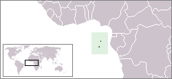
Location map for the São Tomé and Príncipe.
Originally created for English Wikipedia by Vardion.
| This work has been released into the public domain by its author, Vardion. This applies worldwide. In some countries this may not be legally possible; if so: |
Dîroka daneyê
Ji bo dîtina guhartoya wê demê bişkoka dîrokê bitikîne.
| Dîrok/Katjimêr | Wêneyê biçûk | Mezinahî | Bikarhêner | Şirove | |
|---|---|---|---|---|---|
| niha | 22:34, 30 tebax 2011 | | 250 x 115 (7 KB) | Hoshie | added South Sudan |
| 22:54, 12 kanûna pêşîn 2004 |  | 250 x 115 (6 KB) | EugeneZelenko | Location map for the São Tomé and Príncipe.<br/>Originally created for English Wikipedia by Vardion.<br/>{{PD}}<br/>Category:Country locator maps |
Bikaranîna pelê
Rûpelekî ku ji vê dosyeyê bi kar tîne nîne.
Bikaranîna gerdûnî ya pelê
Ev wîkiyên di rêzê de vê pelê bi kar tînin:
- Bikaranîna di als.wikipedia.org de
- Bikaranîna di am.wikipedia.org de
- Bikaranîna di ar.wikipedia.org de
- Bikaranîna di azb.wikipedia.org de
- Bikaranîna di ban.wikipedia.org de
- Bikaranîna di be-tarask.wikipedia.org de
- Bikaranîna di be.wikipedia.org de
- Bikaranîna di bg.wikipedia.org de
- Bikaranîna di bjn.wikipedia.org de
- Bikaranîna di bo.wikipedia.org de
- Bikaranîna di br.wikipedia.org de
- Bikaranîna di bs.wikipedia.org de
- Bikaranîna di ca.wikipedia.org de
- Bikaranîna di ckb.wikipedia.org de
- Bikaranîna di de.wikipedia.org de
- Bikaranîna di de.wikinews.org de
- Bikaranîna di de.wikivoyage.org de
- Bikaranîna di de.wiktionary.org de
- Bikaranîna di dsb.wikipedia.org de
- Bikaranîna di en.wikipedia.org de
- User:DanielZM/test
- User:Chris huh/List of African countries
- Portal:Africa/Countries/Selected country
- Portal:Africa/Countries/Selected country/40
- Outline of São Tomé and Príncipe
- List of São Tomé and Príncipe–related topics
- United Nations Security Council Resolution 373
- Portal:São Tomé and Príncipe/Intro
- List of moths of São Tomé and Príncipe
- List of butterflies of São Tomé and Príncipe
- Bikaranîna di en.wikinews.org de
- Bikaranîna di en.wikivoyage.org de
- Bikaranîna di en.wiktionary.org de
- Bikaranîna di eo.wikipedia.org de
- Bikaranîna di es.wikipedia.org de
- Bikaranîna di es.wikinews.org de
- Bikaranîna di ext.wikipedia.org de
- Bikaranîna di fa.wikipedia.org de
- Bikaranîna di fa.wikivoyage.org de
- Bikaranîna di fiu-vro.wikipedia.org de
- Bikaranîna di fo.wikipedia.org de
- Bikaranîna di frp.wikipedia.org de
- Bikaranîna di fr.wikipedia.org de
Zêdetir bikaranîna global a vê pelê bibîne.