Wêne:Caucasus region 1994.jpg

Mezinahiya vê pêşdîtinê: 782 × 600 pîksel. Resolusyonên din: 313 × 240 pîksel | 626 × 480 pîksel | 1002 × 768 pîksel | 1280 × 982 pîksel | 2560 × 1963 pîksel | 3119 × 2392 pîksel.
Dosyeya orjînal (3119 × 2392 pixel, mezinbûnê data: 1,18 MB, MIME-typ: image/jpeg)
| Ev pel ji Wikimedia Commonsê ye. Agahdariya li ser rûpela danasîna pelê li jêr tê nîşandan. |
| Danasîn |
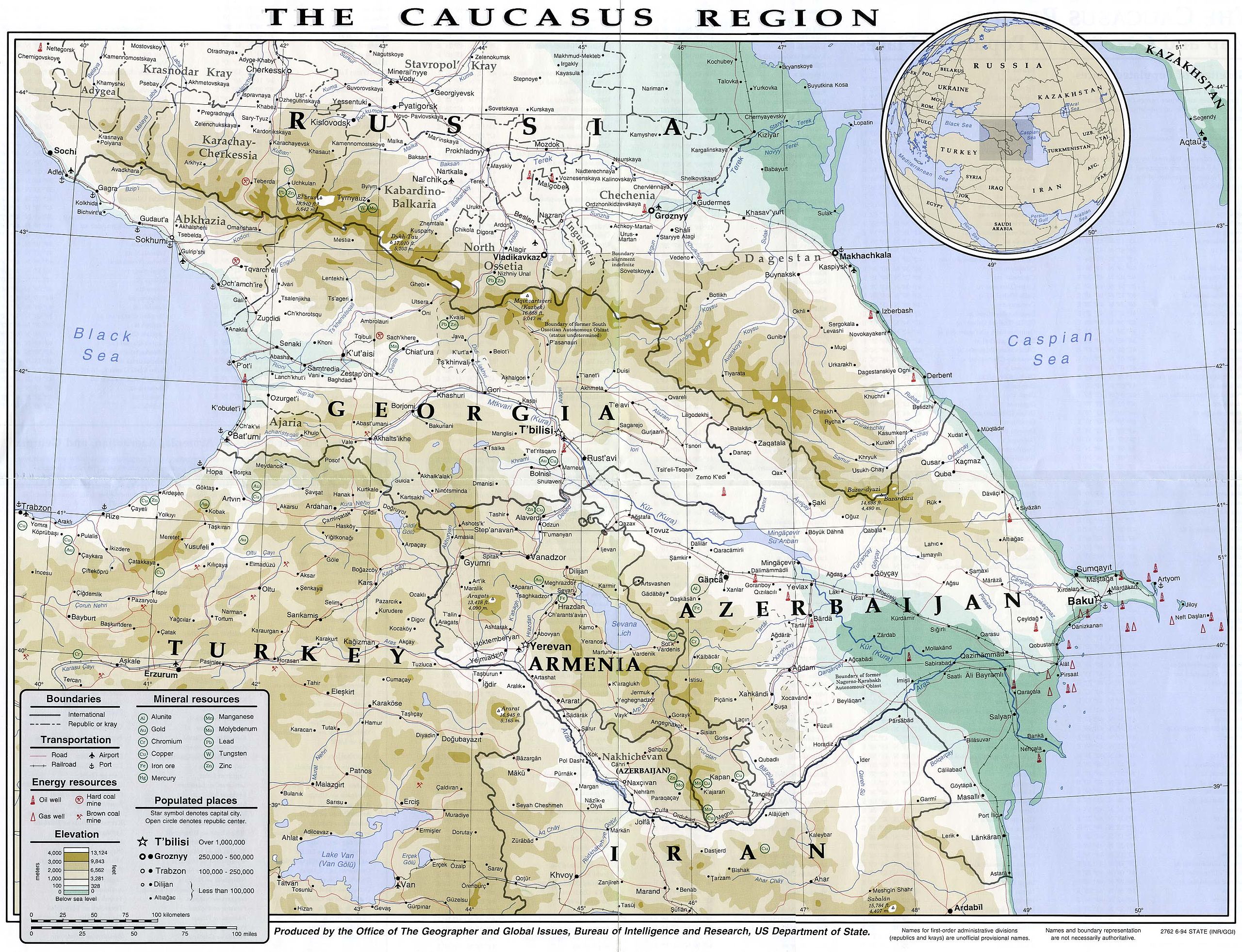
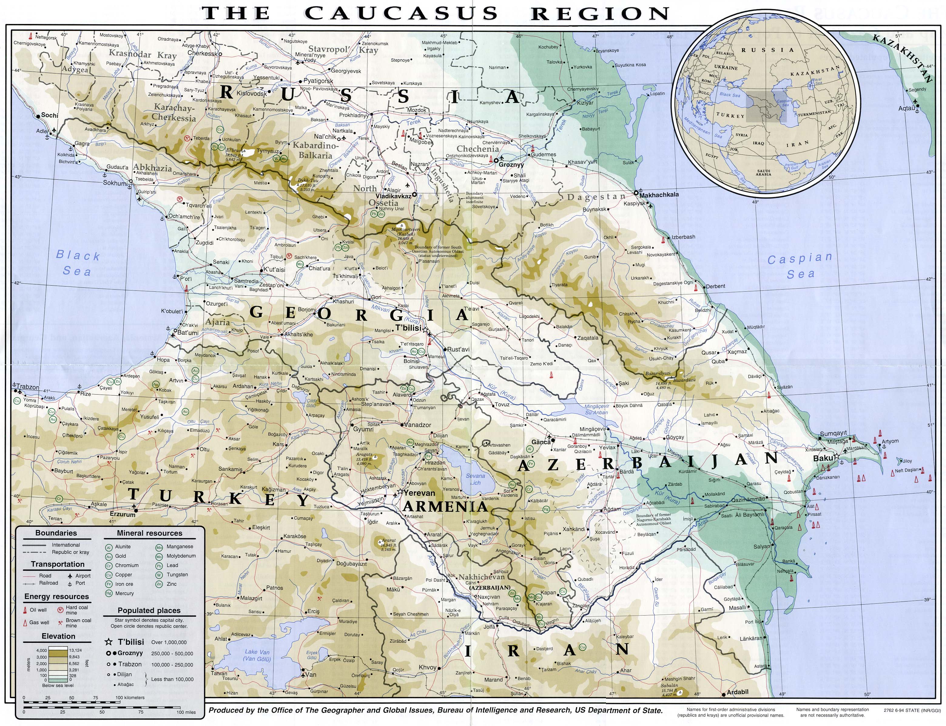
English: Map of the Caucasus region in 1994
Français : Carte du Caucase en 1994 |
|||
| Dîrok | ||||
| Çavkanî | University of Texas Library | |||
| Xwedî | CIA | |||
| Destûr (Dîsa bikaranînê vê dosyeye) |
|
|||
| Guhartoyên din |


Dîroka daneyê
Ji bo dîtina guhartoya wê demê bişkoka dîrokê bitikîne.
| Dîrok/Katjimêr | Wêneyê biçûk | Mezinahî | Bikarhêner | Şirove | |
|---|---|---|---|---|---|
| niha | 14:49, 16 tîrmeh 2007 | | 3119 x 2392 (1,18 MB) | Pmx | {{Information |Description= {{en|Map of the Caucasus region in 1994}} {{fr|Carte du Caucase en 1994}} |Source=University of Texas Library [http://www.lib.utexas.edu/maps/commonwealth/caucasus_region_1994.jpg] |Date=1994 |Author=CIA |Permission=Public doma |
Bikaranîna pelê
Ev 2 rûpel li jêr vê dosyeyê bi kar tînin:
Bikaranîna gerdûnî ya pelê
Ev wîkiyên di rêzê de vê pelê bi kar tînin:
- Bikaranîna di ar.wikipedia.org de
- Bikaranîna di arz.wikipedia.org de
- Bikaranîna di ast.wikipedia.org de
- Bikaranîna di azb.wikipedia.org de
- Bikaranîna di az.wikipedia.org de
- Bikaranîna di ba.wikipedia.org de
- Bikaranîna di bg.wikipedia.org de
- Bikaranîna di bh.wikipedia.org de
- Bikaranîna di bs.wikipedia.org de
- Bikaranîna di ca.wikipedia.org de
- Bikaranîna di de.wikivoyage.org de
- Bikaranîna di en.wikipedia.org de
- Bikaranîna di eo.wikipedia.org de
- Bikaranîna di eu.wikipedia.org de
- Bikaranîna di fr.wikipedia.org de
- Bikaranîna di ga.wikipedia.org de
- Bikaranîna di he.wikipedia.org de
- Bikaranîna di hif.wikipedia.org de
- Bikaranîna di hr.wikipedia.org de
- Bikaranîna di hu.wikipedia.org de
- Bikaranîna di id.wikipedia.org de
- Bikaranîna di it.wikipedia.org de
- Bikaranîna di it.wikivoyage.org de
- Bikaranîna di kk.wikipedia.org de
- Bikaranîna di ko.wikipedia.org de
- Bikaranîna di ml.wikipedia.org de
- Bikaranîna di ms.wikipedia.org de
- Bikaranîna di pnb.wikipedia.org de
- Bikaranîna di pt.wikipedia.org de
- Bikaranîna di ro.wikipedia.org de
- Bikaranîna di sl.wikipedia.org de
- Bikaranîna di so.wikipedia.org de
- Bikaranîna di su.wikipedia.org de
- Bikaranîna di sv.wikivoyage.org de
- Bikaranîna di ta.wikipedia.org de
- Bikaranîna di tg.wikipedia.org de
- Bikaranîna di th.wikipedia.org de
- Bikaranîna di tl.wikipedia.org de
- Bikaranîna di tr.wikipedia.org de
Zêdetir bikaranîna global a vê pelê bibîne.