Wêne:Arab population israel 2000 en.png
Dosyeya orjînal(692 × 1575 pixel, mezinbûnê data: 182 KB, MIME-typ: image/png)


Danasîn

Danasîn
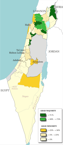
English: Map of the officials 50 "natural regions" of Israel, with their proportions of arab population. The map includ the Golan heights and east Jerusalem, two areas annexed by Israel, annexions not recognize by UNO. The map is based on the demographic situation 2000, and is based upon the arab population in Israel [PDF], a publication (Statistilite N°27) of the israeli Center Bureau of Statistics (CBS) diffused in november 2002.
Français : Carte des 50 "régions naturelles" officiellement reconnues par l'état, subdivision des 15 sous-districts, avec la proportion de population arabe. Cette carte inclue Jérusalem-Est et le plateau du Golan, tous deux annexés par Israël, mais dont l'annexion n'est pas reconnue par l'ONU. La carte est basée sur la situation de la population en l'an 2000, et est inspirée de the arab population in Israel [PDF], une publication (Statistilite N°27) du Center Bureau of Statistics israélien (CBS) diffusée en novembre 2002.
Dîrok
Çavkanî Own work, derivative work of: File:Israel population density.png
Xwedî Christophe cagé
Guhartoyên din File:Arabe population israel 2000 fr.png

Lîsans

© The copyright holder of this file, Israel Central Bureau of Statistics, allows anyone to use it for any purpose, provided that the copyright holder is properly attributed. Redistribution, derivative work, commercial use, and all other use is permitted.
Lê bar kirin:
The Central Bureau of Statistics (CBS), {{{filename}}}, ({{{access-date}}}), [{{{link}}} available online] copied and distributed as is in accordance with the CBS license.

{{{template}}} According to the CBS license, you may not make the following use of the Information, whether by positive act or by omission:
  • present the Information in a misleading manner;
  • present the Information in a way that suggests that the Central Bureau of Statistics, or the State of Israel, supports or endorses you or your use of the Information;
  • make use of the Information in a manner that breaches any applicable law;
  • make use of the Information in a manner that infringes a person's privacy, including merging the Information with other sources of information with the intent of attempting to identify any individual person, business or organization;
  • present the Information in such a manner that gives the appearance that you may have received, or had access to, information held by the Office about any identifiable individual person, business or organization.
I, the copyright holder of this work, hereby publish it under the following licenses:
GNU head Ev dosye di bin Lîsansa Belgekirina Azad a GNU hate barkirin.

Kopîkirin, belavkirin û guhartin di bin qebûlkirinên lîsansa GNU de ye, versiyona 1.2 versiyoneke kevintirîn a belavkirinê ya ji bo Weqfa Nivîsbara Azad, tê qebûlkirin. Kopyeyek lîsanse di beşa bi sernavê Lîsansa Belgekirina Azad a GNUde cî digre.

w:en:Creative Commons
isnad parvekirinê mîna hev
This file is licensed under the Creative Commons Attribution-Share Alike 3.0 Unported, 2.5 Generic, 2.0 Generic and 1.0 Generic license.
Tu azad î:
  • parve bike – ji bo kopîkirin, belavkirin û weşandina xebatê
  • ji bo guhartin û adaptekirina naverokê – ji bo adaptekirina xebatê
Di bin van mercan de:
  • isnad – Divê tu isnadeke maqûl bikî, lînekek pêşkêş bikî ji bo lîsansê, û diyar bikî ku guhartin hatiye kirin an na. Tu dikarî vê yekê bi adilî bi cih bînî, lê ne bi awayê ku wekî lîsansor te an bikaranîna te pejirandibe.
  • parvekirinê mîna hev – Ger tu materyalê biguherînî, bizivirînî formeke din, an ava bikî divê beşdariyên xwe di bin eynî lîsansê an lîsansa hevaheng de wekî ya eslî belav bikî.
Tu dikarî lîsansa ku tu dixwazî hilbijêrî.

Captions

Add a one-line explanation of what this file represents

Items portrayed in this file

motîv Kurdish (Latin script) (transliterated)

some value

URL Kurdish (Latin script) (transliterated): https://commons.wikimedia.org/wiki/user:Christophe_cag%C3%A9
kurteya navê nivîskarî Kurdish (Latin script) (transliterated): Christophe cagé

rewşa mafê telîfê Kurdish (Latin script) (transliterated)

copyrighted îngilîzî

dema avabûnê Kurdish (Latin script) (transliterated)

22 sibat 2009

MIME type îngilîzî

image/png

checksum îngilîzî

5afc0b91dfe8d983a85af862f3a58ec981a8a743

determination method îngilîzî: SHA-1 îngilîzî

data size îngilîzî

186.138 byte

1575 pixel

panî Kurdish (Latin script) (transliterated)

692 pixel

Dîroka daneyê

Ji bo dîtina guhartoya wê demê bişkoka dîrokê bitikîne.

Dîrok/KatjimêrWêneyê biçûkMezinahîBikarhênerŞirove
niha13:48, 15 tîrmeh 2014Versiyona biçûkkirî yê 13:48, 15 tîrmeh 2014692 x 1575 (182 KB)Hruska~commonswikiReverted to version as of 08:23, 22 February 2009
13:47, 15 tîrmeh 2014Versiyona biçûkkirî yê 13:47, 15 tîrmeh 2014692 x 1575 (182 KB)Hruska~commonswikiReverted to version as of 08:23, 22 February 2009 Revert Edit, The Golan and East Jerusalem de facto Israel, Syria giving Status qo
13:46, 15 tîrmeh 2014Versiyona biçûkkirî yê 13:46, 15 tîrmeh 2014692 x 1575 (182 KB)Hruska~commonswikiReverted to version as of 08:23, 22 February 2009
15:38, 21 nîsan 2009Versiyona biçûkkirî yê 15:38, 21 nîsan 2009692 x 1575 (165 KB)MeteorMaker~commonswiki{{Information |Description={{en|1=Map of the officials 50 "natural regions" of Israel, with their proportions of arab population. The map includ the Golan heights and east Jerusalem, two areas annexed by Israel, annexions not recognize by UNO. The map is
08:23, 22 sibat 2009Versiyona biçûkkirî yê 08:23, 22 sibat 2009692 x 1575 (182 KB)Christophe cagé{{Information |Description={{en|1=x}} {{fr|1=x}} |Source=travail personnel (own work) |Author=Christophe cagé |Date=22 february 2009 |Permission=SEE LICENSE |other_versions= }} <!--{{ImageUpload|full}}-->

Ev rûpelên li jêr vê dosyeyê bi kar tînin:

Bikaranîna gerdûnî ya pelê

Ev wîkiyên di rêzê de vê pelê bi kar tînin:

Daneyên meta