Wêne:Achaemenid Empire 500 BC.png

Mezinahiya vê pêşdîtinê: 800 × 427 pîksel. Resolusyonên din: 320 × 171 pîksel | 640 × 341 pîksel | 1024 × 546 pîksel | 1280 × 683 pîksel | 3070 × 1637 pîksel.
Dosyeya orjînal (3070 × 1637 pixel, mezinbûnê data: 811 KB, MIME-typ: image/png)
| Ev pel ji Wikimedia Commonsê ye. Agahdariya li ser rûpela danasîna pelê li jêr tê nîşandan. |
Danasîn
| Danasîn |
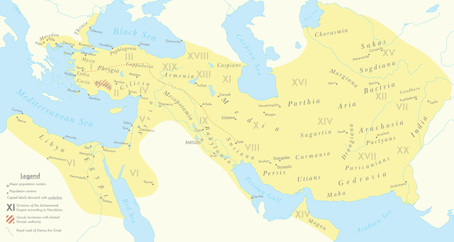
English: A map of the Achaemenid Empire around 500 BC featuring ancient regions, settlements and Satrapies. This map assembles information from the Historischer Schul-Atlas zur alten, mittleren und neueren Geschichte by Heinrich Kiepert and Carl Wolff from 1879 as accessed from GEI Digital, the 1923 edition of Historical Atlas by William R. Shepherd as accessed from the Perry-Castañeda Library's online map collection and Livius.org's article on the Satrapies of the Achaemenid Empire according to Herodotus. |
| Dîrok | |
| Çavkanî | Min çêkir |
| Xwedî | Cattette |
Lîsans
I, the copyright holder of this work, hereby publish it under the following license:
This file is licensed under the Creative Commons Attribution 4.0 International license.
- Tu azad î:
- parve bike – ji bo kopîkirin, belavkirin û weşandina xebatê
- ji bo guhartin û adaptekirina naverokê – ji bo adaptekirina xebatê
- Di bin van mercan de:
- isnad – Divê tu isnadeke maqûl bikî, lînekek pêşkêş bikî ji bo lîsansê, û diyar bikî ku guhartin hatiye kirin an na. Tu dikarî vê yekê bi adilî bi cih bînî, lê ne bi awayê ku wekî lîsansor te an bikaranîna te pejirandibe.
Dîroka daneyê
Ji bo dîtina guhartoya wê demê bişkoka dîrokê bitikîne.
| Dîrok/Katjimêr | Wêneyê biçûk | Mezinahî | Bikarhêner | Şirove | |
|---|---|---|---|---|---|
| niha | 07:01, 12 adar 2021 | | 3070 x 1637 (811 KB) | Cattette | Changed terminology, added Cyropolis |
| 06:05, 9 adar 2021 |  | 3070 x 1637 (811 KB) | Cattette | Added more cities | |
| 21:52, 8 adar 2021 |  | 3070 x 1637 (807 KB) | Cattette | Removed anachronistic labels, removed Thrace and Macedonia as Satrapies | |
| 20:44, 8 adar 2021 |  | 3070 x 1637 (813 KB) | Cattette | Fixed north eastern border, tweaked satrapies | |
| 18:55, 8 adar 2021 |  | 3070 x 1637 (794 KB) | Cattette | Tweaked borders and satraps | |
| 15:20, 8 adar 2021 |  | 3070 x 1637 (789 KB) | Cattette | Fixed Indian border again, added cities in Greece | |
| 07:02, 8 adar 2021 |  | 3070 x 1637 (785 KB) | Cattette | Stronger color, capitals, more cities, added Indian territories beyond the Indus | |
| 14:26, 7 adar 2021 |  | 2923 x 1637 (729 KB) | Cattette | Uploaded own work with UploadWizard |
Bikaranîna pelê
Ev rûpelên li jêr vê dosyeyê bi kar tînin:
Bikaranîna gerdûnî ya pelê
Ev wîkiyên di rêzê de vê pelê bi kar tînin:
- Bikaranîna di arz.wikipedia.org de
- Bikaranîna di ast.wikipedia.org de
- Bikaranîna di ceb.wikipedia.org de
- Bikaranîna di cs.wikipedia.org de
- Bikaranîna di en.wikipedia.org de
- Bikaranîna di fa.wikipedia.org de
- Bikaranîna di ga.wikipedia.org de
- Bikaranîna di gl.wikipedia.org de
- Bikaranîna di ha.wikipedia.org de
- Bikaranîna di he.wikipedia.org de
- Bikaranîna di ko.wikipedia.org de
- Bikaranîna di pl.wikipedia.org de
- Bikaranîna di tg.wikipedia.org de
- Bikaranîna di www.wikidata.org de