Wêne:Kingdom of kurdistan 1923.png

Mezinahiya vê pêşdîtinê: 666 × 600 pîksel. Resolusyonên din: 267 × 240 pîksel | 533 × 480 pîksel | 853 × 768 pîksel | 1106 × 996 pîksel.
Dosyeya orjînal (1106 × 996 pixel, mezinbûnê data: 256 KB, MIME-typ: image/png)
| Ev pel ji Wikimedia Commonsê ye. Agahdariya li ser rûpela danasîna pelê li jêr tê nîşandan. |

Danasîn
| Danasîn |
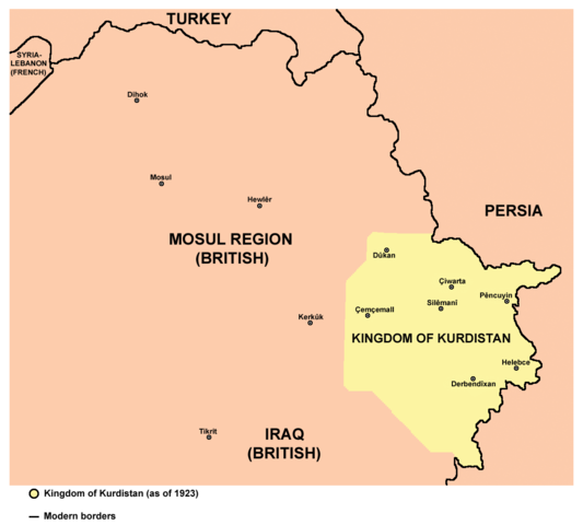
English: Map of the Kingdom of Kurdistan (as of 1923). |
| Dîrok | |
| Çavkanî | Min çêkir |
| Xwedî |
PANONIAN Turkish version: User:Tavukluköy (Yeni Hesap) |
| Guhartoyên din | Turkish, Arabic |
Lîsans
I, the copyright holder of this work, hereby publish it under the following license:
| This file is made available under the Creative Commons CC0 1.0 Universal Public Domain Dedication. | |
| The person who associated a work with this deed has dedicated the work to the public domain by waiving all of their rights to the work worldwide under copyright law, including all related and neighboring rights, to the extent allowed by law. You can copy, modify, distribute and perform the work, even for commercial purposes, all without asking permission.
|
References
Borders of the Kingdom of Kurdistan are made in accordance with this source:
Name of the state:
Locations of main cities and towns:
- http://z5.ifrm.com/30192/69/0/p1104548/IraqKurdistan_2003_2005_lg.gif
- http://hdtravelpictures.com/wp-content/uploads/2011/03/221.gif
Dîroka daneyê
Ji bo dîtina guhartoya wê demê bişkoka dîrokê bitikîne.
| Dîrok/Katjimêr | Wêneyê biçûk | Mezinahî | Bikarhêner | Şirove | |
|---|---|---|---|---|---|
| niha | 15:09, 10 tebax 2014 | | 1106 x 996 (256 KB) | PANONIAN | more cities |
| 11:04, 29 tîrmeh 2014 |  | 1106 x 996 (244 KB) | PANONIAN | {{Information |Description ={{en|1=Map of the Kingdom of Kurdistan (as of 1923).}} |Source ={{own}} |Author =PANONIAN |Date =2014 |Permission = |other_versions = }} |
Bikaranîna pelê
Ev 2 rûpel li jêr vê dosyeyê bi kar tînin:
Bikaranîna gerdûnî ya pelê
Ev wîkiyên di rêzê de vê pelê bi kar tînin:
- Bikaranîna di de.wikipedia.org de
- Bikaranîna di en.wikipedia.org de
- Bikaranîna di eo.wikipedia.org de
- Bikaranîna di es.wikipedia.org de
- Bikaranîna di fa.wikipedia.org de
- Bikaranîna di fr.wikipedia.org de
- Bikaranîna di he.wikipedia.org de
- Bikaranîna di hu.wikipedia.org de
- Bikaranîna di it.wikipedia.org de
- Bikaranîna di ko.wikipedia.org de
- Bikaranîna di mzn.wikipedia.org de
- Bikaranîna di nl.wikipedia.org de
- Bikaranîna di pl.wikipedia.org de
- Bikaranîna di ru.wikipedia.org de
- Bikaranîna di sh.wikipedia.org de
- Bikaranîna di simple.wikipedia.org de
- Bikaranîna di sr.wikipedia.org de
- Bikaranîna di sv.wikipedia.org de
- Bikaranîna di www.wikidata.org de
- Bikaranîna di zh.wikipedia.org de