Wêne:Hailstorm.jpg

Mezinahiya vê pêşdîtinê: 800 × 516 pîksel. Resolusyonên din: 320 × 206 pîksel | 640 × 413 pîksel | 1024 × 661 pîksel | 1280 × 826 pîksel | 1848 × 1192 pîksel.
Dosyeya orjînal (1848 × 1192 pixel, mezinbûnê data: 2,28 MB, MIME-typ: image/jpeg)
| Ev pel ji Wikimedia Commonsê ye. Agahdariya li ser rûpela danasîna pelê li jêr tê nîşandan. |
Danasîn
| Şûnda kamerayê | | Ev wêne û yên din li ser OpenStreetMap |
|---|
| Danasîn |
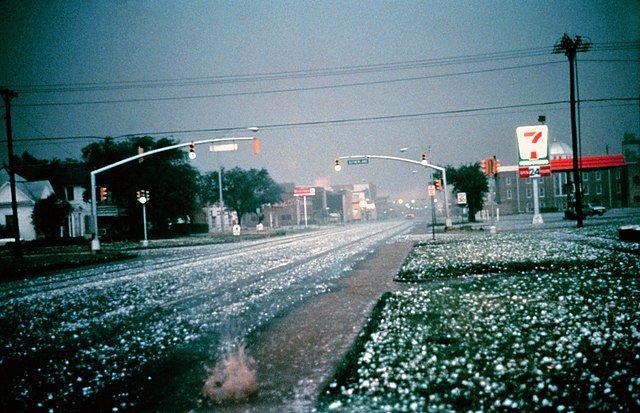
English: Large hail collects on the street and grass during severe thunderstorm. Larger stones appear to be nearly 2 to 3 inches in diameter. Photo taken in Altus, Oklahoma by the NOAA National Severe Storms Laboratory's storm intercept team in the hail core of a supercell thunderstorm that later produced an F2 tornado.
Français : Grosse grêlons de 5 à 8 cm de diamètre lors d'un orage violent. |
| Dîrok | |
| Çavkanî | http://www.photolib.noaa.gov/htmls/nssl0003.htm, http://ewp.nssl.noaa.gov/projects/shave/ |
| Xwedî | NOAA Photo Library, NOAA Central Library; OAR/ERL/National Severe Storms Laboratory (NSSL) |
Lîsans
This image is in the public domain because it contains materials that originally came from the U.S. National Oceanic and Atmospheric Administration, taken or made as part of an employee's official duties.
|
Dîroka daneyê
Ji bo dîtina guhartoya wê demê bişkoka dîrokê bitikîne.
| Dîrok/Katjimêr | Wêneyê biçûk | Mezinahî | Bikarhêner | Şirove | |
|---|---|---|---|---|---|
| niha | 01:53, 5 sibat 2011 | | 1848 x 1192 (2,28 MB) | Supportstorm | Higher Resolution/ Removed Dust |
| 09:54, 2 çiriya pêşîn 2005 |  | 800 x 516 (70 KB) | Tony Rotondas | {{english}} Hailstorm {{spanish}} Tormenta de granizo {{PD-USGov-NOAA}} |
Bikaranîna pelê
Ev rûpelên li jêr vê dosyeyê bi kar tînin:
Bikaranîna gerdûnî ya pelê
Ev wîkiyên di rêzê de vê pelê bi kar tînin:
- Bikaranîna di af.wikipedia.org de
- Bikaranîna di an.wikipedia.org de
- Bikaranîna di ast.wikipedia.org de
- Bikaranîna di bg.wikipedia.org de
- Bikaranîna di ca.wikipedia.org de
- Bikaranîna di ca.wikibooks.org de
- Bikaranîna di de.wikibooks.org de
- Bikaranîna di en.wikibooks.org de
- Bikaranîna di eo.wikipedia.org de
- Bikaranîna di es.wikipedia.org de
- Bikaranîna di fr.wikipedia.org de
- Bikaranîna di fr.wiktionary.org de
- Bikaranîna di gl.wikipedia.org de
- Bikaranîna di he.wikipedia.org de
- Bikaranîna di hr.wikipedia.org de
- Bikaranîna di hu.wikipedia.org de
- Bikaranîna di incubator.wikimedia.org de
- Bikaranîna di is.wikipedia.org de
- Bikaranîna di is.wiktionary.org de
- Bikaranîna di nl.wikipedia.org de
- Bikaranîna di nl.wikibooks.org de
- Bikaranîna di no.wikipedia.org de
- Bikaranîna di pl.wikipedia.org de
- Bikaranîna di pl.wikiquote.org de
- Bikaranîna di pl.wiktionary.org de
- Bikaranîna di sr.wikipedia.org de
- Bikaranîna di th.wikipedia.org de
- Bikaranîna di vi.wiktionary.org de
- Bikaranîna di wa.wiktionary.org de
- Bikaranîna di wuu.wikipedia.org de
- Bikaranîna di zh.wikipedia.org de