Wêne:Dead Sea Galilee.jpg

Mezinahiya vê pêşdîtinê: 363 × 600 pîksel. Resolusyonên din: 145 × 240 pîksel | 290 × 480 pîksel | 465 × 768 pîksel | 1162 × 1920 pîksel.
Dosyeya orjînal (1162 × 1920 pixel, mezinbûnê data: 645 KB, MIME-typ: image/jpeg)
| Ev pel ji Wikimedia Commonsê ye. Agahdariya li ser rûpela danasîna pelê li jêr tê nîşandan. |
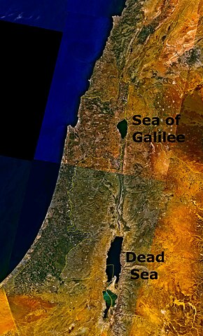
Outdated 1948-1967 geopolitical map depicting Jordanian conquest territory with Dead Sea and the w:Sea of Galilee.
| This image is in the public domain because it is a screenshot from NASA’s globe software World Wind using a public domain layer, such as Blue Marble, MODIS, Landsat, SRTM, USGS or GLOBE.
|
 |
Dîroka daneyê
Ji bo dîtina guhartoya wê demê bişkoka dîrokê bitikîne.
| Dîrok/Katjimêr | Wêneyê biçûk | Mezinahî | Bikarhêner | Şirove | |
|---|---|---|---|---|---|
| niha | 18:07, 24 tebax 2006 | | 1162 x 1920 (645 KB) | Interiot~commonswiki | The Dead Sea and the w:Sea of Galilee. Imagery from NASA World Wind. {{PD-USGov-NASA}} Category:Satellite pictures of IsraelCategory:Satellite pictures of Jordan |
Bikaranîna pelê
Ev rûpelên li jêr vê dosyeyê bi kar tînin:
Bikaranîna gerdûnî ya pelê
Ev wîkiyên di rêzê de vê pelê bi kar tînin:
- Bikaranîna di bn.wikipedia.org de
- Bikaranîna di ckb.wikipedia.org de
- Bikaranîna di da.wikipedia.org de
- Bikaranîna di el.wiktionary.org de
- Bikaranîna di en.wikipedia.org de
- Bikaranîna di en.wiktionary.org de
- Bikaranîna di fo.wikipedia.org de
- Bikaranîna di fr.wiktionary.org de
- Bikaranîna di fy.wikipedia.org de
- Bikaranîna di id.wikipedia.org de
- Bikaranîna di kn.wikipedia.org de
- Bikaranîna di ml.wikipedia.org de
- Bikaranîna di ms.wikipedia.org de
- Bikaranîna di pt.wikipedia.org de
- Bikaranîna di ro.wikipedia.org de
- Bikaranîna di sc.wikipedia.org de
- Bikaranîna di simple.wikipedia.org de
- Bikaranîna di sl.wikipedia.org de
- Bikaranîna di sw.wikipedia.org de
- Bikaranîna di te.wiktionary.org de
- Bikaranîna di ur.wikipedia.org de
- Bikaranîna di zh.wikipedia.org de
- Bikaranîna di zh.wiktionary.org de